Close Menu
  • Home
  • Maritime
  • Offshore
  • Port
  • Oil & Gas
  • Energy
  • Technology
  • Incidents
  • Environment
  • Events
    • Maritime
    • Offshore
    • Oil & Gas
    • Energy
  • Advertising
  • Contact
Facebook X (Twitter) Instagram LinkedIn
Trending
  • European refiners could drive green hydrogen momentum, with maritime sector playing important role
  • North Sea yields ‘significant’ black gold discovery
  • Falmouth Scientific, Inc. Receives ISO 9001:2015 Quality Certification
  • New leadership for Oceanbird – Splash247
  • Boats Group lawsuit alleges monopoly in US listings
  • Hollandse Kust West Beta cable tests completed
  • New Fred. Olsen 1848 floating solar lead brings experience from SolarDuck, Equinor
  • Strohm’s TCP jumpers make their way to Malaysian deepwater sector
Facebook X (Twitter) Instagram LinkedIn
Maritime247.comMaritime247.com
  • Home
  • Maritime
  • Offshore
  • Port
  • Oil & Gas
  • Energy
  • Tech
  • Incidents
  • Environment
  • Events
    • Maritime
    • Oil & Gas
    • Offshore
    • Energy
  • Advertising
Maritime247.comMaritime247.com
Home»Technology»Satellites Help NOC Track Tidal Change for Safer Port Operations
Technology

Satellites Help NOC Track Tidal Change for Safer Port Operations

May 13, 2025
Facebook Twitter LinkedIn WhatsApp Reddit Tumblr Email
Share
Facebook Twitter LinkedIn Email

Revolutionizing Port Management: How Satellite Data is Changing the Game

Port management is a complex and crucial aspect of maritime operations, especially in busy and dynamic waterways like the Mersey River. Scientists at the UK’s National Oceanography Centre (NOC) in Liverpool have recently made significant strides in using satellite data to provide valuable insights into the Mersey River, ultimately revolutionizing how port operators manage navigation channels.

Mapping Changes from Space

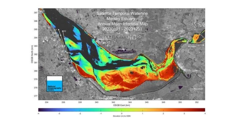
Through a project funded by the UK Space Agency and in collaboration with the Channel Coastal Observatory (CCO) and Peel Ports Group, NOC’s scientists have demonstrated that changes in areas exposed at low tide can be effectively mapped using satellite data. This breakthrough allows port operators to anticipate and address issues such as sand or mud movements that could potentially block navigation channels.

Enhancing Navigational Safety

Regular monitoring of an estuary the size of the Mersey River can be challenging and costly using traditional survey methods. However, the use of satellite imagery combined with data from the Gladstone Tide Gauge and the SWOT satellite has enabled a more precise understanding of tidal water levels and riverbed changes from 2018 to 2023. This information is invaluable for planning dredging operations efficiently and ensuring navigational safety.

Proactive Management Strategies

Russell Bird, Deputy Group Harbour Master at Peel Ports Group, highlights the significance of this technology in enhancing navigational safety and dredging strategies. The ability to proactively manage significant changes in the river allows for more efficient operations and cost savings in the long run.

Leading the Way in Coastal Management

The success of this project showcases Liverpool’s position at the forefront of utilizing satellite technology for coastal management challenges. The methods developed by NOC have the potential to benefit other regions in the UK and beyond, setting a new standard for port management practices.

See also  Nanoplastics Abound in the North Atlantic

Overall, the integration of satellite data into port management practices marks a significant step forward in optimizing operations, ensuring safety, and minimizing costs in dynamic waterways like the Mersey River. The collaboration between scientific research institutions, government agencies, and industry partners demonstrates the power of innovation in addressing complex maritime challenges.

Change NOC Operations Port Safer Satellites tidal Track
Share. Facebook Twitter LinkedIn Tumblr Telegram Email

Related Posts

Falmouth Scientific, Inc. Receives ISO 9001:2015 Quality Certification

August 21, 2025

Antarctica Undergoing Abrupt Change

August 21, 2025

Reach Subsea Completes Inspection for TotalEnergies Using USV/ Electric ROV

August 21, 2025
Top Posts

Duties of Bosun (Boatswain) on a Ship

February 1, 2025

Top 16 Biggest LNG Ships

April 16, 2025

Sea-Doo Switch recall underway after serious safety concerns

March 2, 2025

China Fights Australia’s Plans to Reclaim Darwin Port Citing U.S. Influence

May 27, 2025
Don't Miss
Maritime

Norwegian man wakes up to containership in his garden

May 24, 2025

Imagine the consternation of waking up to find a huge containership in your garden. This…

ECO Liberty Service Operations Vessel Launched To

June 30, 2025

UN reviews regulation as seafarers revealed to work 74% above global average

February 7, 2025

GT Wings wins £1M grant to advance AirWing jet sail technology

July 25, 2025

Subscribe to Updates

Your Weekly Dive into Maritime & Energy News.

About Us
About Us

Stay informed with the latest in maritime, offshore, oil & gas, and energy industries. Explore news, trends, and insights shaping the global energy landscape.

For advertising inquiries, contact us at
info@maritime247.com.

Facebook X (Twitter) YouTube LinkedIn
Our Picks

Cellula Robotics Expands AUV Market Reach in Northern Europe

May 19, 2025

Taihan’s Palos CLV Installs Export Cables for South Korean Offshore Wind Farm

July 16, 2025

Bering Yachts moves aluminium catamaran work to Bulgaria

March 9, 2025

Subscribe to Updates

Your Weekly Dive into Maritime & Energy News.

© 2025 maritime247.com - All rights reserved.
  • Contact
  • Privacy Policy
  • Terms & Conditions
  • Advertising

Type above and press Enter to search. Press Esc to cancel.