Close Menu
  • Home
  • Maritime
  • Offshore
  • Port
  • Oil & Gas
  • Energy
  • Technology
  • Incidents
  • Environment
  • Events
    • Maritime
    • Offshore
    • Oil & Gas
    • Energy
  • Advertising
  • Contact
Facebook X (Twitter) Instagram LinkedIn
Trending
  • ECO Liberty SOV Hits Water to Support Equinor’s Empire Wind Project
  • U.S. Navy is Using AI to Plan Out Drone Swarm Operations
  • South Korea’s first specialized HVDC installation vessel to be built by Turkish shipyard
  • Finland bans ship waste discharges in first for maritime environmental law
  • Weco’s improved wave energy converter taking shape (Video)
  • Canada’s huge Shell-led export project achieves its first LNG cargo
  • First interior images of recovered superyacht Bayesian revealed
  • Denmark Grants Life Extension for Two Pioneering Wind Farms
Facebook X (Twitter) Instagram LinkedIn
Maritime247.comMaritime247.com
  • Home
  • Maritime
  • Offshore
  • Port
  • Oil & Gas
  • Energy
  • Tech
  • Incidents
  • Environment
  • Events
    • Maritime
    • Oil & Gas
    • Offshore
    • Energy
  • Advertising
Maritime247.comMaritime247.com
Home»Technology»NOAA’s PORTS® System Expands Operations to Include Pearl Harbor-Honolulu
Technology

NOAA’s PORTS® System Expands Operations to Include Pearl Harbor-Honolulu

May 29, 2025
Facebook Twitter LinkedIn WhatsApp Reddit Tumblr Email
Share
Facebook Twitter LinkedIn Email

NOAA’s PORTS® System Enhances Maritime Safety in Pearl Harbor-Honolulu

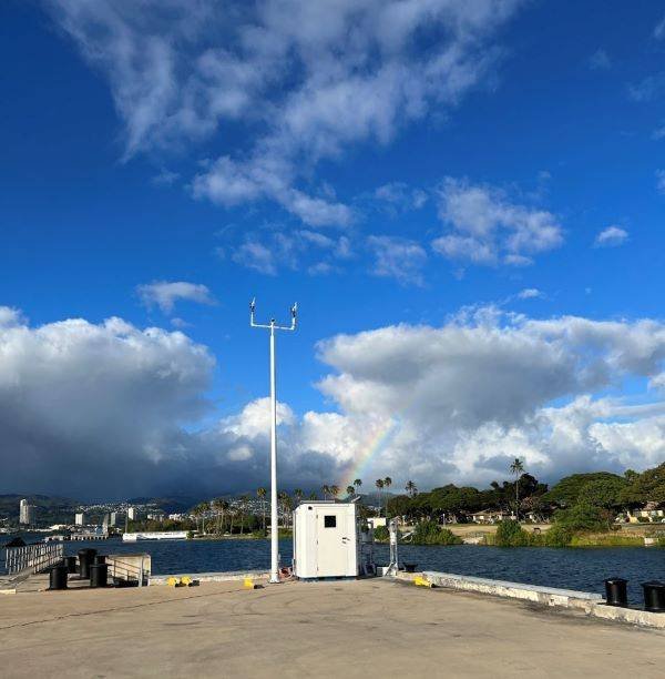
NOAA’s first Physical Oceanographic Real-time System, or PORTS®, at Pearl Harbor-Honolulu, Hawaii, is now operational. Installed by NOAA’s National Ocean Service, data from the new publicly available observation system advances NOAA’s ability to better serve Hawaii’s coastal communities and secure maritime safety in the Pacific Islands.

Enhancing Safety and Operations

Pearl Harbor-Honolulu PORTS is NOAA’s 40th system in this national network of precision marine navigation sensors concentrated in busy U.S. seaports, and is the result of a partnership between NOAA and U.S. Navy Region Hawaii. Data from the system will be used to assist in the Navy’s planning and monitoring during daily operations and hazardous weather situations in Pearl Harbor and on Joint Base Pearl Harbor-Hickam.

Commercial and local mariners traveling to Honolulu Harbor will have access to these real-time observations, enabling safer vessel movement, cargo capacity assessment, and reduced transit delays for commercial traffic. Honolulu Harbor handles more than 11 million tons of cargo annually.

Key Features of the PORTS® System

The Pearl Harbor-Honolulu PORTS consists of one water level and meteorological station located in Pearl Harbor (Ford Island) and a buoy-mounted current meter at Ford Island Channel, Lighted Buoy #1, sponsored by the U.S. Navy. The system collects data on wind, air temperature, air pressure, and tidal currents to assist mariners in safe docking in adverse weather conditions and heavy ship traffic.

Additionally, the system integrates data from a NOAA National Water Level Observation Network station at Honolulu Harbor and a Coastal Data Information Program wave buoy at the entrance to Pearl Harbor.

See also  IQAX becomes first to launch DCSA-compliant eBL on GSBN

Benefits of PORTS® Program

PORTS® is a successful public-private partnership program that provides real-time environmental data to vessel operators in seaports, supporting safe vessel movements and reducing maritime accidents. The new Pearl Harbor-Honolulu PORTS® system, maintained by NOAA, will contribute to the safety and economic benefits of the program.

The integration of the PORTS® system in Pearl Harbor-Honolulu enhances maritime safety, supports military operations, and improves efficiency for commercial and local mariners navigating the busy seaport. The availability of real-time data will enable proactive measures in response to hazardous weather conditions and coastal flooding impacts, benefiting the community and the economy.

expands HarborHonolulu include NOAAs Operations Pearl Ports System
Share. Facebook Twitter LinkedIn Tumblr Telegram Email

Related Posts

U.S. Navy is Using AI to Plan Out Drone Swarm Operations

July 1, 2025

ECO Liberty Service Operations Vessel Launched To

June 30, 2025

Triton Anchor Gets Patents for Floating Renewables Anchoring Tech

June 30, 2025
Top Posts

Car Carrier ‘Morning Midas’ Catches Fire with Electric Vehicles Off Alaska

June 5, 2025

China Fights Australia’s Plans to Reclaim Darwin Port Citing U.S. Influence

May 27, 2025

Denmark awards first-ever offshore wind farm life extension permit

June 4, 2025

Fire-Stricken Wan Hai 503 Continues to Drift Off Indian Coast as Salvage Efforts Intensify

June 11, 2025
Don't Miss
Offshore

Journey from oil & gas to other markets: Malaysian firm buys cable laying barge

April 16, 2025

Keyfield International Ventures into Cable Laying Business with Acquisition of Cable Laying Barge Keyfield International,…

Sea-Cargo retrofitting RoRo pair to cut fossil fuel use by up to 50%

April 3, 2025

BP to slash over 5% of workforce

January 16, 2025

How tomorrow’s ships will operate

May 30, 2025

Subscribe to Updates

Your Weekly Dive into Maritime & Energy News.

About Us
About Us

Stay informed with the latest in maritime, offshore, oil & gas, and energy industries. Explore news, trends, and insights shaping the global energy landscape.

For advertising inquiries, contact us at
info@maritime247.com.

Facebook X (Twitter) YouTube LinkedIn
Our Picks

Odfjell Drilling-managed rig to spud wildcat pair offshore Norway

May 11, 2025

New Funding to Advance Hull Cleaning and Inspection Robot Deployment

January 17, 2025

Santos’ giant gas project off north Australia gets environmental nod

April 29, 2025

Subscribe to Updates

Your Weekly Dive into Maritime & Energy News.

© 2025 maritime247.com - All rights reserved.
  • Contact
  • Privacy Policy
  • Terms & Conditions
  • Advertising

Type above and press Enter to search. Press Esc to cancel.