Close Menu
  • Home
  • Maritime
  • Offshore
  • Port
  • Oil & Gas
  • Energy
  • Technology
  • Incidents
  • Environment
  • Events
    • Maritime
    • Offshore
    • Oil & Gas
    • Energy
  • Advertising
  • Contact
Facebook X (Twitter) Instagram LinkedIn
Trending
  • European refiners could drive green hydrogen momentum, with maritime sector playing important role
  • North Sea yields ‘significant’ black gold discovery
  • Falmouth Scientific, Inc. Receives ISO 9001:2015 Quality Certification
  • New leadership for Oceanbird – Splash247
  • Boats Group lawsuit alleges monopoly in US listings
  • Hollandse Kust West Beta cable tests completed
  • New Fred. Olsen 1848 floating solar lead brings experience from SolarDuck, Equinor
  • Strohm’s TCP jumpers make their way to Malaysian deepwater sector
Facebook X (Twitter) Instagram LinkedIn
Maritime247.comMaritime247.com
  • Home
  • Maritime
  • Offshore
  • Port
  • Oil & Gas
  • Energy
  • Tech
  • Incidents
  • Environment
  • Events
    • Maritime
    • Oil & Gas
    • Offshore
    • Energy
  • Advertising
Maritime247.comMaritime247.com
Home»Technology»Trapped Wave Mystery Solved
Technology

Trapped Wave Mystery Solved

June 5, 2025
Facebook Twitter LinkedIn WhatsApp Reddit Tumblr Email
Share
Facebook Twitter LinkedIn Email

The Mystery of the Mega Tsunamis in Greenland Unraveled by Satellite Altimetry

In a groundbreaking study led by Oxford University, a new type of satellite altimetry has finally confirmed the theory behind the extraordinary global tremors observed in September – October 2023. The cause of these seismic anomalies was identified as two mega tsunamis in Greenland that became trapped as standing waves, shaking the Earth in a puzzling rhythm.

The Seismic Puzzle Unveiled

In September 2023, a strange global seismic signal was detected, occurring every 90 seconds over nine days, and then repeated a month later. After almost a year of speculation, two scientific studies proposed that two mega tsunamis were triggered in Greenland’s remote Dickson fjord by major landslides caused by glacier warming. These waves were believed to have become trapped in the fjord system, forming standing waves that created the mysterious signals.

Despite these theories, there were no direct observations of the trapped waves to confirm the hypothesis. Even a Danish military vessel that visited the fjord during the first seismic event did not witness the waves causing the seismic disturbances.

Satellite Altimetry: Unveiling the Waves

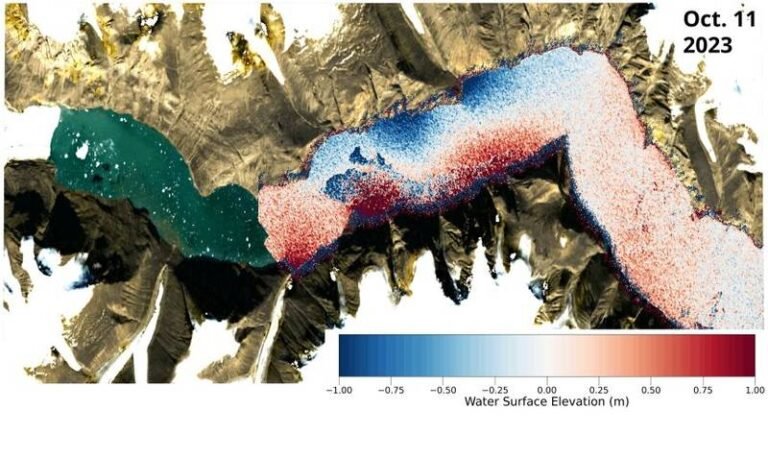
The Oxford researchers utilized innovative analysis techniques to interpret satellite altimetry data, measuring the height of the Earth’s surface, including the ocean. Traditional satellite altimeters were unable to capture evidence of the trapped waves due to long observation gaps and limited 1D surface profiles. However, the new Surface Water Ocean Topography (SWOT) satellite, equipped with the Ka-band Radar Interferometer (KaRIn) instrument, provided a breakthrough in capturing detailed water height measurements.

See also  2024 was Hottest Year on Record

By analyzing the KaRIn data, the researchers created elevation maps of the Greenland Fjord following the tsunamis, revealing clear cross-channel slopes with height differences up to two meters. These slopes indicated water movement back and forth across the channel, validating the theory of trapped standing waves.

Connecting the Dots

To confirm their findings, the researchers correlated the observed wave characteristics with small Earth crust movements measured thousands of kilometers away. By reconstructing weather and tidal conditions, they ruled out wind or tide-induced phenomena as the cause of the observed seismic signals.

The study, titled ‘Observations of the seiche that shook the world,’ has been published in Nature Communications, shedding light on the mystery of the mega tsunamis in Greenland and showcasing the power of satellite altimetry in unraveling seismic puzzles.

mystery Solved Trapped wave
Share. Facebook Twitter LinkedIn Tumblr Telegram Email

Related Posts

Falmouth Scientific, Inc. Receives ISO 9001:2015 Quality Certification

August 21, 2025

Antarctica Undergoing Abrupt Change

August 21, 2025

Reach Subsea Completes Inspection for TotalEnergies Using USV/ Electric ROV

August 21, 2025
Top Posts

Duties of Bosun (Boatswain) on a Ship

February 1, 2025

China Fights Australia’s Plans to Reclaim Darwin Port Citing U.S. Influence

May 27, 2025

Fire-Stricken Wan Hai 503 Continues to Drift Off Indian Coast as Salvage Efforts Intensify

June 11, 2025

Sea-Doo Switch recall underway after serious safety concerns

March 2, 2025
Don't Miss
Port

Donald Trump Supports ILA Leadership in Fight Over Port Automation

December 24, 2024

President-elect Trump Supports Longshoremen’s Fight Against Automation in U.S. Ports President-elect Donald Trump has shown…

Attack on Guyana, Exxon Would Be ‘Bad Day’ for Venezuela, Rubio Warns

March 29, 2025

NOC Awarded $3.5m to Explore Expanding Ocean Desertification

May 24, 2025

MODEC and Samsung Team Up to Install Carbon Capture Tech on FPSO

February 27, 2025

Subscribe to Updates

Your Weekly Dive into Maritime & Energy News.

About Us
About Us

Stay informed with the latest in maritime, offshore, oil & gas, and energy industries. Explore news, trends, and insights shaping the global energy landscape.

For advertising inquiries, contact us at
info@maritime247.com.

Facebook X (Twitter) YouTube LinkedIn
Our Picks

NAVTOR Sets Up Shop In United Arab Emirates

July 6, 2025

Scotland greenlights mammoth offshore wind project

August 1, 2025

Emirates Team New Zealand splits with Peter Burling

April 13, 2025

Subscribe to Updates

Your Weekly Dive into Maritime & Energy News.

© 2025 maritime247.com - All rights reserved.
  • Contact
  • Privacy Policy
  • Terms & Conditions
  • Advertising

Type above and press Enter to search. Press Esc to cancel.