Close Menu
  • Home
  • Maritime
  • Offshore
  • Port
  • Oil & Gas
  • Energy
  • Technology
  • Incidents
  • Environment
  • Events
    • Maritime
    • Offshore
    • Oil & Gas
    • Energy
  • Advertising
  • Contact
Facebook X (Twitter) Instagram LinkedIn
Trending
  • ECO Liberty Service Operations Vessel Launched To
  • U.S.-Built ECO Liberty Ushers in New Era for American Offshore Wind Vessels
  • AAL: Sixth methanol-ready MPP newbuild delivered
  • Two more multimillion-dollar vessel gigs land on DOF’s task list in Brazilian waters
  • Triton Anchor Gets Patents for Floating Renewables Anchoring Tech
  • Ukraine May Pursue Sanctions Against Bangladeshi Buyers of Stolen Grain
  • Ocean Installer wins North Sea work with Vår Energi
  • Landmark carbon capture pilot completed in China
Facebook X (Twitter) Instagram LinkedIn
Maritime247.comMaritime247.com
  • Home
  • Maritime
  • Offshore
  • Port
  • Oil & Gas
  • Energy
  • Tech
  • Incidents
  • Environment
  • Events
    • Maritime
    • Oil & Gas
    • Offshore
    • Energy
  • Advertising
Maritime247.comMaritime247.com
Home»Technology»High-Resolution Mapping Reveals Carbon Sink Details
Technology

High-Resolution Mapping Reveals Carbon Sink Details

June 30, 2025
Facebook Twitter LinkedIn WhatsApp Reddit Tumblr Email
Share
Facebook Twitter LinkedIn Email

A Breakthrough in Mapping the Ocean Carbon Sink

A new satellite-based product can now map the ocean carbon sink at unprecedented resolution.

Although the oceanic sink for the human-induced carbon dioxide reduces global warming, there are significant biogeochemical consequences. This uptake leads to a reduction in seawater pH and alters the carbonate chemistry of the ocean. These changes in ocean chemistry, often collectively referred to as ocean acidification, impact marine organisms and alter marine ecosystems.

Understanding Short-Term Variability

Scientists have made progress in understanding how the global ocean carbon sink changes over seasons and decades. However, the short-term variability is still not well understood. Most global datasets currently used to study the ocean carbon sink only provide monthly data and have a resolution of about 100 by 100 kilometers. This limited temporal and spatial resolution makes it difficult to capture the finer, more dynamic changes governing the ocean sink.

The OceanSODA-ETHZ Product

Nicolas Gruber, from the ETH Zurich University in Switzerland, led the development of a new version of the OceanSODA-ETHZ product. This global, gridded dataset of surface ocean carbon dioxide and the ocean carbonate system is designed for studying the ocean carbon sink and ocean acidification over seasonal to decadal timescales.

The new version maps the parameters of the ocean carbon system every eight days at a resolution of about 25 by 25 kilometers, more than 30 times finer than previous products. Satellite data is a critical part of the approach, providing detailed information to interpolate the measurements in time and space.

Visualizing the Data

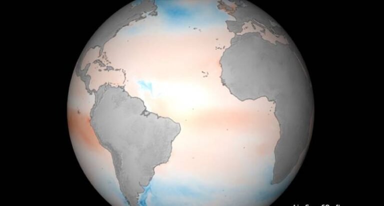
An animation shows differences in the exchange of carbon dioxide between the air and the sea, capturing the period encompassing numerous hurricanes in the Atlantic ocean. Blue regions indicate carbon dioxide uptake by the ocean, while red regions show where carbon dioxide is being released to the atmosphere. Wind arrows depict surface ocean currents.

See also  Landmark carbon capture pilot completed in China

Professor Jamie Shutler, from the University of Exeter’s Department of Earth and Environmental Science, highlighted the dataset’s fine detail in understanding events like hurricanes, which can cause sudden spikes or changes in surface ocean carbon dioxide levels.

Implications for Climate Change

By capturing small-scale changes, this new product opens up opportunities to study how the ocean absorbs carbon and how this process might change in the future against the backdrop of climate change. Understanding the ocean carbon sink at this resolution can provide valuable insights into marine ecosystems and global carbon cycling.

carbon details HighResolution Mapping Reveals Sink
Share. Facebook Twitter LinkedIn Tumblr Telegram Email

Related Posts

Triton Anchor Gets Patents for Floating Renewables Anchoring Tech

June 30, 2025

Landmark carbon capture pilot completed in China

June 30, 2025

TotalEnergies Hires Shearwater for 3D Survey in Africa

June 29, 2025
Top Posts

Car Carrier ‘Morning Midas’ Catches Fire with Electric Vehicles Off Alaska

June 5, 2025

China Fights Australia’s Plans to Reclaim Darwin Port Citing U.S. Influence

May 27, 2025

Denmark awards first-ever offshore wind farm life extension permit

June 4, 2025

Fire-Stricken Wan Hai 503 Continues to Drift Off Indian Coast as Salvage Efforts Intensify

June 11, 2025
Don't Miss
Offshore

EnerMech bags Gulf of Mexico decommissioning deal with ExxonMobil

June 18, 2025

ExxonMobil Awards EnerMech Decommissioning Contract for Gulf of Mexico Fields US supermajor ExxonMobil has recently…

MPCC Sells Five Container Ships as Part of Fleet Optimization Effort

March 27, 2025

Klaipėda Port kicks off quay electrification project

February 10, 2025

Northern Drilling semisub gets more work off Namibia

June 20, 2025

Subscribe to Updates

Your Weekly Dive into Maritime & Energy News.

About Us
About Us

Stay informed with the latest in maritime, offshore, oil & gas, and energy industries. Explore news, trends, and insights shaping the global energy landscape.

For advertising inquiries, contact us at
info@maritime247.com.

Facebook X (Twitter) YouTube LinkedIn
Our Picks

Old Doha Port launches Minakom digital platform for maritime tourists

May 19, 2025

Nationwide Strike Paralyzes Belgium’s Ports, Airports, and Services

March 31, 2025

The Quantum Economy

January 24, 2025

Subscribe to Updates

Your Weekly Dive into Maritime & Energy News.

© 2025 maritime247.com - All rights reserved.
  • Contact
  • Privacy Policy
  • Terms & Conditions
  • Advertising

Type above and press Enter to search. Press Esc to cancel.