Close Menu
  • Home
  • Maritime
  • Offshore
  • Port
  • Oil & Gas
  • Energy
  • Technology
  • Incidents
  • Environment
  • Events
    • Maritime
    • Offshore
    • Oil & Gas
    • Energy
  • Advertising
  • Contact
Facebook X (Twitter) Instagram LinkedIn
Trending
  • Eni, YPF Sign Agreement On Argentina LNG Project
  • Teledyne Valeport Water Announces Shallow Water Hyperion32
  • Second Bulker Refloated After Grounding off Sweden
  • bound4blue WAPS calculation method wins DNV nod of approval
  • NOAA: Operational Forecast System Informs Shipwreck Oil Spill Scenarios
  • Tourist boat carrying 89 passengers capsizes in Bali
  • Lithuania to relaunch 700MW offshore wind tender next week
  • UML ready to welcome first newbuild tanker fitted with WAPS
Facebook X (Twitter) Instagram LinkedIn
Maritime247.comMaritime247.com
  • Home
  • Maritime
  • Offshore
  • Port
  • Oil & Gas
  • Energy
  • Tech
  • Incidents
  • Environment
  • Events
    • Maritime
    • Oil & Gas
    • Offshore
    • Energy
  • Advertising
Maritime247.comMaritime247.com
Home»Maritime»China Surveys Vietnamese Naval Base Using U.S. Satellite Data
Maritime

China Surveys Vietnamese Naval Base Using U.S. Satellite Data

February 19, 2025
Facebook Twitter LinkedIn WhatsApp Reddit Tumblr Email
Share
Facebook Twitter LinkedIn Email

Vietnam Accelerates Land Reclamation in Spratly Islands

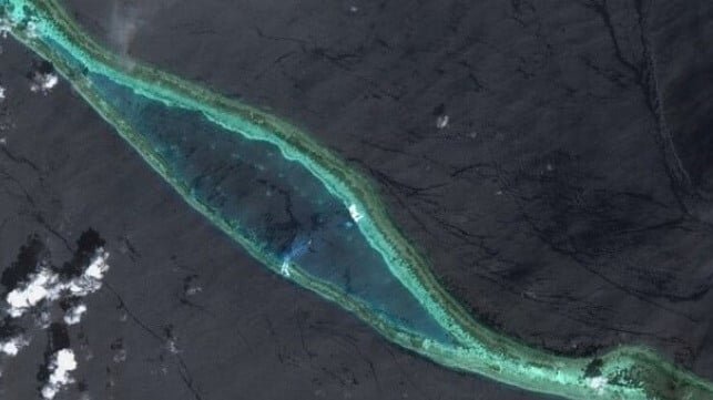
Over the past year, Vietnam has ramped up its land reclamation efforts in the Spratly Islands, expanding its military bases at a rapid pace compared to other claimants in the region. According to a recent paper released by China’s Ministry of Natural Resources, Vietnam has made significant progress, particularly at its largest facility on Barque Canada Reef.

The paper, published in the Journal of Tropical Oceanography, details a method that combines data from American and European satellites to accurately map out the depth of a newly dug ship channel at Barque Canada Reef. By utilizing NASA’s ICESat-2 satellite with laser sensing capabilities and high-resolution optical imaging from the EU’s Sentinel satellite constellation, researchers were able to measure the channel’s depth with precision without the need for on-site surveying.

The study revealed that the channel is deep enough to accommodate warships as large as the PLA Navy’s Type 055 destroyers, which draw about 22 feet of water. This development signifies Vietnam’s strategic military expansion in the region, with nearly 500 acres added to Barque Canada Reef in just two years.

Coauthor Fu Dongyang noted that these changes have significantly altered the reef’s topography, providing Vietnam with additional space for potential military uses. With approximately 16,000 acres of natural coral flats on the shoal, there is ample room for further development, similar to what China has done on neighboring reefs like Mischief Reef and Fiery Cross Reef.

The Spratly Islands remain a hotspot for territorial disputes, with multiple countries claiming ownership over various parts of the archipelago. Vietnam’s expansion efforts serve as a means to bolster its security perimeter in the South China Sea, where tensions with neighboring countries, including China, continue to simmer.

See also  China Allows European Representatives to Board Ship Linked to Cable Breach Case

In a statement to the Washington Post, Vietnamese foreign policy director Le Dinh Tinh emphasized the country’s commitment to defending its interests in the region by any means necessary. As Vietnam asserts its presence in the Spratly Islands, the geopolitical landscape in the South China Sea continues to evolve.

Base China Data Naval satellite Surveys U.S Vietnamese
Share. Facebook Twitter LinkedIn Tumblr Telegram Email

Related Posts

Eni, YPF Sign Agreement On Argentina LNG Project

June 8, 2025

Second Bulker Refloated After Grounding off Sweden

June 8, 2025

Tourist boat carrying 89 passengers capsizes in Bali

June 8, 2025
Top Posts

Duties of Bosun (Boatswain) on a Ship

February 1, 2025

Top 10 Biggest RORO Ships In The World

February 15, 2025

Sea-Doo Switch recall underway after serious safety concerns

March 2, 2025

CMA CGM settles US sexual harassment case

January 11, 2025
Don't Miss
Port

Ukraine Plans to Lease Out the Black Sea Port of Chornomorsk

May 5, 2025

Ukraine Unveils 40-Year Concession Plan for Black Sea Port of Chornomorsk Ukraine recently announced a…

Qatar’s LNG fleet expansion coming along as Hanwha cuts steel for 8 newbuilds

March 12, 2025

Two Namibian prospects on TotalEnergies’ drilling agenda in 2025 as it puts off FID for oil discovery

February 6, 2025

Cadeler Welcomes Wind Pace WTIV Newbuild to its Fleet

March 27, 2025

Subscribe to Updates

Your Weekly Dive into Maritime & Energy News.

About Us
About Us

Stay informed with the latest in maritime, offshore, oil & gas, and energy industries. Explore news, trends, and insights shaping the global energy landscape.

For advertising inquiries, contact us at
info@maritime247.com.

Facebook X (Twitter) YouTube LinkedIn
Our Picks

Next Ukraine Ceasefire Talks Will Focus on Black Sea Shipping

March 21, 2025

Sonardyne Unveils SPRINT-Nav DP

February 5, 2025

U.S. Coast Guard Releases Audio of Lost Submersible’s Implosion

February 13, 2025

Subscribe to Updates

Your Weekly Dive into Maritime & Energy News.

© 2025 maritime247.com - All rights reserved.
  • Contact
  • Privacy Policy
  • Terms & Conditions
  • Advertising

Type above and press Enter to search. Press Esc to cancel.