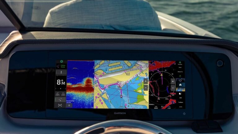
Marine electronics manufacturer Garmin has expanded its range of GPSMAP plotters with the launch of the GPSMAP 15×3 chartplotter. The chartplotter is Garmin’s first to offer an ultrawide 15-inch touchscreen and is designed to enable users to benefit from ‘the advantages of dual screens without needing two separate units’. With a high-resolution display and edge-to-edge glass format the GPSMAP 15×3 chartplotter is designed to fit a wide range of dash configurations.
The new plotter joins the GPSMAP range, with Garmin having launched the GPSMAP 16×3 last year.
Susan Lyman, Garmin vice president of global consumer sales & marketing, says: “We are excited to add an ultrawide display option to our popular GPSMAP x3 chartplotter series that offers boaters and anglers a more expansive, immersive field of view. Coupled with its easy-to-use functionality, built-in mapping and superior sonar capabilities, the GPSMAP 15×3 delivers an incredible experience at the helm.”
The product announcement follows Garmin posting record Q1 revenue in 2025, as reported by MIN
The benefits of an ultrawide chartplotter
The ultrawide display is optimised for viewing applications side by side and uses sidebar controls so boaters can customise and view the data they use most without switching screens.
The GPSMAP 15×3 chartplotter offers built-in sonar, including ultra high-definition (UHD) ClearVü and SideVü scanning sonars as well as supporting optional Panoptix, LiveScope and CHIRP traditional sonar.
Users can also build an onboard marine system with compatible sonar, autopilot, radars, instruments, stereos, cameras and more using NMEA networks or the Garmin Marine Network.
The GPSMAP 15×3 offers two different mounting options – a bail-mount with inset knobs and a bracket to support floating display installations; and a rear-mount option for secure flush and flat-mount helm solutions.
The system has built-in Garmin Navionics+ integrated mapping, which includes Auto Guidance+ technology3 and a one-year plan for downloadable daily updates. Users can also add Garmin Navionics Vision+ for premium features like high-resolution relief shading, satellite imagery and more.
Chartplotting for anglers
When integrated with a Garmin Force trolling motor, anglers can create routes, patterns and tracks for the trolling motor to follow while they fish. From the chartplotter screen, they can also control speed, check battery life and more.
Owners can also view essential engine information such as RPMs, fuel flow and more for compatible engine manufacturers.
By utilising Garmin’s EmpirBus, owners can use digital switching to control lighting, power management and more – or the OneHelm integrated solutions allow users to control third party systems and devices.

