Close Menu
  • Home
  • Maritime
  • Offshore
  • Port
  • Oil & Gas
  • Energy
  • Technology
  • Incidents
  • Environment
  • Events
    • Maritime
    • Offshore
    • Oil & Gas
    • Energy
  • Advertising
  • Contact
Facebook X (Twitter) Instagram LinkedIn
Trending
  • HD Hyundai, H-Line Shipping to develop AI-powered autonomous ship technology
  • Panama’s Comptroller Asks Court to Void Hutchison’s Terminal Concession
  • New 500 kV submarine cable contract to keep ZTT busy offshore China
  • India commissions 1 MW green hydrogen plant at Kandla Port
  • BP renews EnerMech’s contract for work across Caribbean platforms
  • Nexans, Crowley Wind Services to Build Cable Lay Barge for US Ops
  • How marine service providers are helping shipping meet its sustainability goals
  • Garmin Q2 results show growth in all business segments
Facebook X (Twitter) Instagram LinkedIn
Maritime247.comMaritime247.com
  • Home
  • Maritime
  • Offshore
  • Port
  • Oil & Gas
  • Energy
  • Tech
  • Incidents
  • Environment
  • Events
    • Maritime
    • Oil & Gas
    • Offshore
    • Energy
  • Advertising
Maritime247.comMaritime247.com
Home»Maritime»Philippines Says Chinese Sea Gliders Were Used for Covert Mapping
Maritime

Philippines Says Chinese Sea Gliders Were Used for Covert Mapping

April 16, 2025
Facebook Twitter LinkedIn WhatsApp Reddit Tumblr Email
Share
Facebook Twitter LinkedIn Email

Chinese Seaglider Drones Found in Philippine Waters

Between 2022 and 2024, Philippine fishermen made a startling discovery – five suspicious seaglider drones scattered across strategic locations between Luzon and Mindanao. Upon further investigation, it was revealed that these drones were designed for collecting data related to “underwater warfare,” as confirmed by the Armed Forces of the Philippines.

During a recent press conference, AFP spokesman Rear Admiral Roy Vincent Trinidad disclosed that the drones were strategically placed in areas crucial for national defense and international maritime navigation. The devices were located in the Taiwan Strait off Luzon, near Masbate, and off Mindanao. Trinidad suggested that these drones were most likely dropped by a mothership.

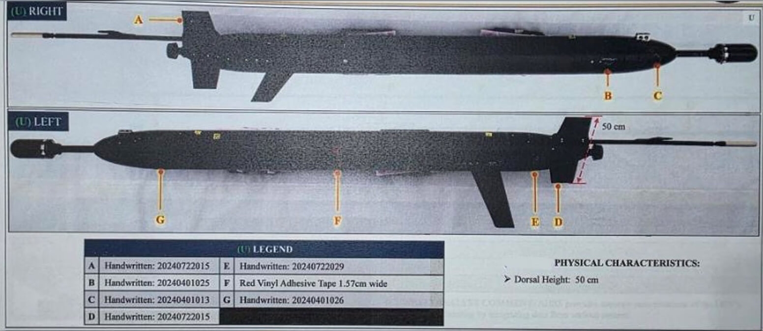
The capabilities of these drones extended beyond basic navigation data. Equipped with sensors for measuring bathymetry, water depth, salinity, and temperature, they were well-suited for gathering information necessary for submarine operations. Jonathan Malaya, a member of the National Task Force for the Philippine Sea, asserted that these drones were likely deployed by China to map the underwater terrain of the Philippines.

Forensic examinations of the drones revealed compelling evidence linking them to China. One drone had sent signals to mainland China via a cell SIM card found onboard, while two drones bore Chinese markings. Trinidad estimated the probability of Chinese ownership at 55-80 percent, while Malaya confidently stated that the forensic data conclusively proved their Chinese origin.

Photos of the drones displayed during the press conference bore resemblance to the Chinese-built “Sea Wing” UUV, developed by the Chinese Academy of Sciences. Notably, one drone stood out due to its all-black design and unique protrusions.

See also  After 10-Month Voyage, Chinese Ship Returns With Key Modules Destined For Russia

The unveiling of this forensic evidence coincides with the upcoming U.S.-Philippine Balikatan defense drills, where 14,000 troops, predominantly from the United States, will participate. According to Philippine Army Brigadier General Michael Logico, the drills serve as a crucial test of defense strategies.

As tensions rise, Google Maps has made a significant gesture by adopting the Philippine’s name for waters in its western exclusive economic zone – now labeled as the West Philippine Sea. This move, challenging China’s claim over the region, has sparked controversy among Chinese commentators who advocate for retaining the name “South China Sea.”

Chinese Covert gliders Mapping Philippines Sea
Share. Facebook Twitter LinkedIn Tumblr Telegram Email

Related Posts

Panama’s Comptroller Asks Court to Void Hutchison’s Terminal Concession

July 31, 2025

Garmin Q2 results show growth in all business segments

July 31, 2025

US Treasury unleashes largest Iran shipping sanctions since 2018

July 31, 2025
Top Posts

Duties of Bosun (Boatswain) on a Ship

February 1, 2025

China Fights Australia’s Plans to Reclaim Darwin Port Citing U.S. Influence

May 27, 2025

Fire-Stricken Wan Hai 503 Continues to Drift Off Indian Coast as Salvage Efforts Intensify

June 11, 2025

Car Carrier ‘Morning Midas’ Catches Fire with Electric Vehicles Off Alaska

June 5, 2025
Don't Miss
Oil & Gas

Australian player eyeing entry into Namibia’s frontier basin

April 18, 2025

Grand Gulf Energy Eyes Acquisition of Petroleum Exploration License in Offshore Namibia Australia-headquartered exploration and…

World’s First Hybrid Roller Coaster and Water Slide Revealed By Norwegian Cruise Line

March 30, 2025

VARD launches hybrid cable lay & construction vessel for Japanese offshore wind (Video)

July 4, 2025

Crew Member Missing from Rio Tinto’s Bulk Carrier Heading to Australia

January 2, 2025

Subscribe to Updates

Your Weekly Dive into Maritime & Energy News.

About Us
About Us

Stay informed with the latest in maritime, offshore, oil & gas, and energy industries. Explore news, trends, and insights shaping the global energy landscape.

For advertising inquiries, contact us at
info@maritime247.com.

Facebook X (Twitter) YouTube LinkedIn
Our Picks

Tariff uncertainty continues as Trump hits pause for 90 days

April 10, 2025

PSA Antwerp joins Zero Emission Port Alliance to drive decarbonization

July 27, 2025

CMA CGM Commits to Modernize Syria’s Latakia Port with New 30-Year Deal

May 2, 2025

Subscribe to Updates

Your Weekly Dive into Maritime & Energy News.

© 2025 maritime247.com - All rights reserved.
  • Contact
  • Privacy Policy
  • Terms & Conditions
  • Advertising

Type above and press Enter to search. Press Esc to cancel.