Close Menu
  • Home
  • Maritime
  • Offshore
  • Port
  • Oil & Gas
  • Energy
  • Technology
  • Incidents
  • Environment
  • Events
    • Maritime
    • Offshore
    • Oil & Gas
    • Energy
  • Advertising
  • Contact
Facebook X (Twitter) Instagram LinkedIn
Trending
  • bound4blue WAPS calculation method wins DNV nod of approval
  • NOAA: Operational Forecast System Informs Shipwreck Oil Spill Scenarios
  • Tourist boat carrying 89 passengers capsizes in Bali
  • Lithuania to relaunch 700MW offshore wind tender next week
  • UML ready to welcome first newbuild tanker fitted with WAPS
  • Mother Ship with USV Flotilla Could Boost Coast Guard Capabilities
  • New Zealand To Ban Substandard Ships From Entering Its Ports
  • Noble bags drillship work in Papua New Guinea with TotalEnergies
Facebook X (Twitter) Instagram LinkedIn
Maritime247.comMaritime247.com
  • Home
  • Maritime
  • Offshore
  • Port
  • Oil & Gas
  • Energy
  • Tech
  • Incidents
  • Environment
  • Events
    • Maritime
    • Oil & Gas
    • Offshore
    • Energy
  • Advertising
Maritime247.comMaritime247.com
Home»Technology»Saildrone, Meta Complete First Unmanned, Autonomous Deep-Water Cable Route Survey in the North Atlantic
Technology

Saildrone, Meta Complete First Unmanned, Autonomous Deep-Water Cable Route Survey in the North Atlantic

June 4, 2025
Facebook Twitter LinkedIn WhatsApp Reddit Tumblr Email
Share
Facebook Twitter LinkedIn Email

Saildrone Completes Groundbreaking Deep-Water Cable Route Survey in the North Atlantic

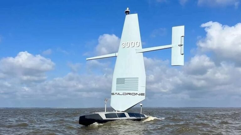
In a first-of-its-kind demonstration mission, Saildrone, in partnership with Meta, successfully completed a deep-water cable route survey in the North Atlantic using the Saildrone Surveyor, a 20-meter uncrewed surface vehicle (USV). This project represents a milestone in the evolution of ocean survey technology, proving that autonomous platforms can deliver data quality and performance on par with traditional crewed survey vessels—while dramatically reducing risk and cost.

During the 26-day survey conducted in June and July 2024, the Saildrone Surveyor mapped more than 4,500 km of seabed, including complex topographies and challenging conditions, without a port call or outside assistance. Operating under sail and motor-sail modes and equipped with a Kongsberg EM304 MKII multibeam sonar, the Surveyor achieved swath coverage of up to 10 km in water depths of up to 5,500 meters.

The demonstration focused on collecting bathymetric data along the established Anjana cable route and the recently surveyed Aurora route to directly compare the Saildrone Surveyor’s performance against traditional crewed survey vessels. Key operational metrics—route fidelity, line keeping, data transmission, and depth accuracy—met or exceeded expectations across the board.

Using the Saildrone Mission Portal and real-time, high-bandwidth satellite connectivity, Saildrone hydrographic surveyors and pilots monitored vehicle performance and dynamically re-tasked it to investigate features of interest—such as seamounts and canyons—critical for route optimization. Previously limited to crewed vessels, this capability opens the door to more agile, responsive, and distributed survey operations.

A critical focus of the mission was minimizing Health, Safety, and Environmental (HSE) risks associated with offshore operations, demonstrating significant benefits to the quality of life for hydrographic surveyors, cable route engineers, and client representatives who can now perform their work remotely from shore-based offices or home offices, reducing time away from family and minimizing the physical and mental strain associated with offshore deployments. Furthermore, the mission avoided an estimated 243 tons of CO₂ emissions—over 50 times less than a conventional vessel—highlighting the sustainability advantages of uncrewed systems.

See also  TGS Kicks Off 3D Seismic Survey for Floating Wind Farm

This demonstration paves the way for broader adoption of USVs in subsea telecom, offshore energy, and national hydrographic programs. Future developments will focus on expanding operational range, improving weather resilience, and integrating new technologies like AI-based navigation and expendable bathythermographs.

Atlantic Autonomous cable complete deepwater Meta North Route Saildrone Survey Unmanned
Share. Facebook Twitter LinkedIn Tumblr Telegram Email

Related Posts

NOAA: Operational Forecast System Informs Shipwreck Oil Spill Scenarios

June 8, 2025

Mother Ship with USV Flotilla Could Boost Coast Guard Capabilities

June 8, 2025

Next Geosolutions, Green Yard Kleven Convert Vessel for Subsea Surveys

June 7, 2025
Top Posts

Duties of Bosun (Boatswain) on a Ship

February 1, 2025

Top 10 Biggest RORO Ships In The World

February 15, 2025

Sea-Doo Switch recall underway after serious safety concerns

March 2, 2025

CMA CGM settles US sexual harassment case

January 11, 2025
Don't Miss
Offshore

Eni taps Hilong for Congo LNG gig

February 12, 2025

Eni Chinese Firm Hilong Petroleum Secures Contract for Eni’s Congo LNG Project Phase 2 Chinese…

NOC Launches Innovation Hub To Power Ocean Tech And

April 9, 2025

New Emissions Barges Readied to Help California Ports Meet New Rules

December 26, 2024

UK Government Commits £300 Million to Boost Offshore Wind Supply Chain

April 24, 2025

Subscribe to Updates

Your Weekly Dive into Maritime & Energy News.

About Us
About Us

Stay informed with the latest in maritime, offshore, oil & gas, and energy industries. Explore news, trends, and insights shaping the global energy landscape.

For advertising inquiries, contact us at
info@maritime247.com.

Facebook X (Twitter) YouTube LinkedIn
Our Picks

Cairn hires EMGS for 3D survey off India

April 28, 2025

Silicon Sensing, Kongsberg Discovery Join Forces to Develop Gyro Technology

June 2, 2025

Nearly $1B in Drugs Seized at Dutch Ports as Smuggling was Reduced in 2024

January 23, 2025

Subscribe to Updates

Your Weekly Dive into Maritime & Energy News.

© 2025 maritime247.com - All rights reserved.
  • Contact
  • Privacy Policy
  • Terms & Conditions
  • Advertising

Type above and press Enter to search. Press Esc to cancel.