Close Menu
  • Home
  • Maritime
  • Offshore
  • Port
  • Oil & Gas
  • Energy
  • Technology
  • Incidents
  • Environment
  • Events
    • Maritime
    • Offshore
    • Oil & Gas
    • Energy
  • Advertising
  • Contact
Facebook X (Twitter) Instagram LinkedIn
Trending
  • ILO to map gaps in Pakistan shipbreaking in the wake of HKC
  • Seventh FPSO prepares to join Petrobras’ Santos Basin field
  • One of UK’s Largest Cocaine Seizures Made at London Gateway Port
  • Danos Awarded Production Services Contract for Beacon Offshore Energy Deepwater Facility
  • Container Losses At Sea Rise In 2024 Due To Red Sea Disruptions
  • Nexans’ new cable layer traveling from Poland to Norway to finalize construction
  • NTSB Issues Preliminary Report on Mexican Navy Tall Ship Collision with Brooklyn Bridge
  • Second floating solar plant on the way for Norway’s northernmost fish farm
Facebook X (Twitter) Instagram LinkedIn
Maritime247.comMaritime247.com
  • Home
  • Maritime
  • Offshore
  • Port
  • Oil & Gas
  • Energy
  • Tech
  • Incidents
  • Environment
  • Events
    • Maritime
    • Oil & Gas
    • Offshore
    • Energy
  • Advertising
Maritime247.comMaritime247.com
Home»Technology»Satellites Help NOC Track Tidal Change for Safer Port Operations
Technology

Satellites Help NOC Track Tidal Change for Safer Port Operations

May 13, 2025
Facebook Twitter LinkedIn WhatsApp Reddit Tumblr Email
Share
Facebook Twitter LinkedIn Email

Revolutionizing Port Management: How Satellite Data is Changing the Game

Port management is a complex and crucial aspect of maritime operations, especially in busy and dynamic waterways like the Mersey River. Scientists at the UK’s National Oceanography Centre (NOC) in Liverpool have recently made significant strides in using satellite data to provide valuable insights into the Mersey River, ultimately revolutionizing how port operators manage navigation channels.

Mapping Changes from Space

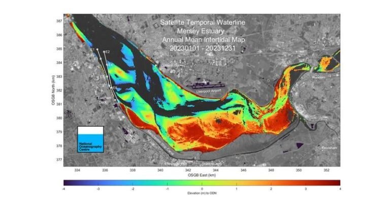
Through a project funded by the UK Space Agency and in collaboration with the Channel Coastal Observatory (CCO) and Peel Ports Group, NOC’s scientists have demonstrated that changes in areas exposed at low tide can be effectively mapped using satellite data. This breakthrough allows port operators to anticipate and address issues such as sand or mud movements that could potentially block navigation channels.

Enhancing Navigational Safety

Regular monitoring of an estuary the size of the Mersey River can be challenging and costly using traditional survey methods. However, the use of satellite imagery combined with data from the Gladstone Tide Gauge and the SWOT satellite has enabled a more precise understanding of tidal water levels and riverbed changes from 2018 to 2023. This information is invaluable for planning dredging operations efficiently and ensuring navigational safety.

Proactive Management Strategies

Russell Bird, Deputy Group Harbour Master at Peel Ports Group, highlights the significance of this technology in enhancing navigational safety and dredging strategies. The ability to proactively manage significant changes in the river allows for more efficient operations and cost savings in the long run.

Leading the Way in Coastal Management

The success of this project showcases Liverpool’s position at the forefront of utilizing satellite technology for coastal management challenges. The methods developed by NOC have the potential to benefit other regions in the UK and beyond, setting a new standard for port management practices.

See also  SMD Celebrates 100th Plough Sale

Overall, the integration of satellite data into port management practices marks a significant step forward in optimizing operations, ensuring safety, and minimizing costs in dynamic waterways like the Mersey River. The collaboration between scientific research institutions, government agencies, and industry partners demonstrates the power of innovation in addressing complex maritime challenges.

Change NOC Operations Port Safer Satellites tidal Track
Share. Facebook Twitter LinkedIn Tumblr Telegram Email

Related Posts

One of UK’s Largest Cocaine Seizures Made at London Gateway Port

July 1, 2025

ECO Liberty Service Operations Vessel Launched To

June 30, 2025

Triton Anchor Gets Patents for Floating Renewables Anchoring Tech

June 30, 2025
Top Posts

Car Carrier ‘Morning Midas’ Catches Fire with Electric Vehicles Off Alaska

June 5, 2025

China Fights Australia’s Plans to Reclaim Darwin Port Citing U.S. Influence

May 27, 2025

Denmark awards first-ever offshore wind farm life extension permit

June 4, 2025

Fire-Stricken Wan Hai 503 Continues to Drift Off Indian Coast as Salvage Efforts Intensify

June 11, 2025
Don't Miss
Offshore

Production of e-Ammonia in Developing Countries Bears Double Costs, Study Shows

March 21, 2025

Components of levelized cost of ammonia (LCOA) and the required offtake price derived from equity…

NOC: Underwater Vehicle Finds Loch Ness Monster Camera Trap

April 1, 2025

Yinson Production’s FPSO with carbon reduction kit ticks pit stop off its list as voyage to Angola continues

May 12, 2025

Shell, BP, TotalEnergies, Eni, Equinor, ExxonMobil, Chevron, and ConocoPhillips score $29 billion

May 12, 2025

Subscribe to Updates

Your Weekly Dive into Maritime & Energy News.

About Us
About Us

Stay informed with the latest in maritime, offshore, oil & gas, and energy industries. Explore news, trends, and insights shaping the global energy landscape.

For advertising inquiries, contact us at
info@maritime247.com.

Facebook X (Twitter) YouTube LinkedIn
Our Picks

Ben Ainslie astounded after INEOS Britannia firing

January 24, 2025

Trump’s offshore wind moratorium details revealed

January 16, 2025

Canopy Power to deliver ‘largest floating solar project in Maldives’ at luxury resort

February 21, 2025

Subscribe to Updates

Your Weekly Dive into Maritime & Energy News.

© 2025 maritime247.com - All rights reserved.
  • Contact
  • Privacy Policy
  • Terms & Conditions
  • Advertising

Type above and press Enter to search. Press Esc to cancel.