The Future of Ocean Data Collection: SeaTrac and Sonardyne Collaboration
For nine days in 2024, SeaTrac and Sonardyne joined forces to revolutionize oceanographic data collection in the U.S. Gulf of Mexico’s Loop Current System (LCS). This collaboration marked the beginning of a groundbreaking project led by the University of Rhode Island (URI), funded by the U.S. National Academy of Sciences.
The Importance of Understanding the Loop Current System
The LCS plays a vital role in various aspects of marine operations, environmental research, and marine life monitoring. However, traditional methods of data collection using manned vessels pose risks to crew members, incur high operational costs, and contribute to greenhouse gas emissions. SeaTrac and Sonardyne’s innovative approach aims to address these challenges.
The Technology Behind the Mission
SeaTrac’s SP-48 uncrewed surface vehicle (USV) is a solar- and battery-powered vessel designed to operate for extended periods in challenging offshore conditions. Equipped with Sonardyne’s HPT 7000L transceiver, the USV can harvest acoustic data from seabed sensors with precision and efficiency.
The Mission Execution
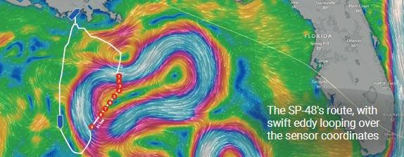
Prior to the mission, Sonardyne and URI deployed acoustic Doppler current profilers and pressure inverted echo sounders on the seabed to collect data on the LCS. The SP-48 was launched from LUMCON in Louisiana and remotely piloted by the SeaTrac team from Massachusetts. Navigating through strong currents and eddies, the USV successfully harvested data from the offshore sensors.
Benefits of Unmanned Data Collection
By utilizing the SP-48 USV and Sonardyne technology, researchers were able to collect valuable data from offshore sensors without the need for crewed vessels. This approach significantly reduced operational costs, carbon emissions, and risks to human safety. The data collected will provide insights into the LCS’s impact on marine life, energy development, fisheries management, and coastal planning.
Future Plans
The Sonardyne sensors will continue to collect long-term data on the LCS, with SeaTrac scheduled to harvest additional sets of data through 2025. Real-time transmission of data via satellite connection from offshore staging points will further enhance the understanding of the Gulf of Mexico’s complex ocean currents.
Overall, the SeaTrac and Sonardyne collaboration represents a milestone in marine robotics and data collection, paving the way for innovative solutions in ocean research and exploration.

