The Mystery of the Mega Tsunamis in Greenland Unraveled by Satellite Altimetry
In a groundbreaking study led by Oxford University, a new type of satellite altimetry has finally confirmed the theory behind the extraordinary global tremors observed in September – October 2023. The cause of these seismic anomalies was identified as two mega tsunamis in Greenland that became trapped as standing waves, shaking the Earth in a puzzling rhythm.
The Seismic Puzzle Unveiled
In September 2023, a strange global seismic signal was detected, occurring every 90 seconds over nine days, and then repeated a month later. After almost a year of speculation, two scientific studies proposed that two mega tsunamis were triggered in Greenland’s remote Dickson fjord by major landslides caused by glacier warming. These waves were believed to have become trapped in the fjord system, forming standing waves that created the mysterious signals.
Despite these theories, there were no direct observations of the trapped waves to confirm the hypothesis. Even a Danish military vessel that visited the fjord during the first seismic event did not witness the waves causing the seismic disturbances.
Satellite Altimetry: Unveiling the Waves
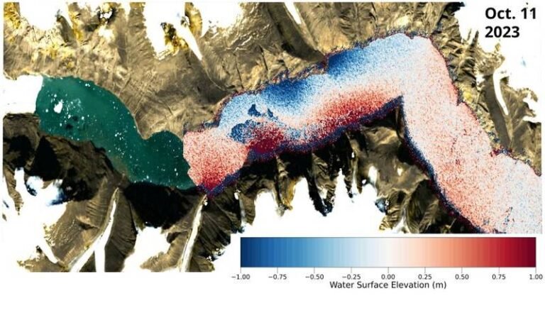
The Oxford researchers utilized innovative analysis techniques to interpret satellite altimetry data, measuring the height of the Earth’s surface, including the ocean. Traditional satellite altimeters were unable to capture evidence of the trapped waves due to long observation gaps and limited 1D surface profiles. However, the new Surface Water Ocean Topography (SWOT) satellite, equipped with the Ka-band Radar Interferometer (KaRIn) instrument, provided a breakthrough in capturing detailed water height measurements.
By analyzing the KaRIn data, the researchers created elevation maps of the Greenland Fjord following the tsunamis, revealing clear cross-channel slopes with height differences up to two meters. These slopes indicated water movement back and forth across the channel, validating the theory of trapped standing waves.
Connecting the Dots
To confirm their findings, the researchers correlated the observed wave characteristics with small Earth crust movements measured thousands of kilometers away. By reconstructing weather and tidal conditions, they ruled out wind or tide-induced phenomena as the cause of the observed seismic signals.
The study, titled ‘Observations of the seiche that shook the world,’ has been published in Nature Communications, shedding light on the mystery of the mega tsunamis in Greenland and showcasing the power of satellite altimetry in unraveling seismic puzzles.

