Close Menu
  • Home
  • Maritime
  • Offshore
  • Port
  • Oil & Gas
  • Energy
  • Technology
  • Incidents
  • Environment
  • Events
    • Maritime
    • Offshore
    • Oil & Gas
    • Energy
  • Advertising
  • Contact
Facebook X (Twitter) Instagram LinkedIn
Trending
  • European refiners could drive green hydrogen momentum, with maritime sector playing important role
  • North Sea yields ‘significant’ black gold discovery
  • Falmouth Scientific, Inc. Receives ISO 9001:2015 Quality Certification
  • New leadership for Oceanbird – Splash247
  • Boats Group lawsuit alleges monopoly in US listings
  • Hollandse Kust West Beta cable tests completed
  • New Fred. Olsen 1848 floating solar lead brings experience from SolarDuck, Equinor
  • Strohm’s TCP jumpers make their way to Malaysian deepwater sector
Facebook X (Twitter) Instagram LinkedIn
Maritime247.comMaritime247.com
  • Home
  • Maritime
  • Offshore
  • Port
  • Oil & Gas
  • Energy
  • Tech
  • Incidents
  • Environment
  • Events
    • Maritime
    • Oil & Gas
    • Offshore
    • Energy
  • Advertising
Maritime247.comMaritime247.com
Home»Technology»NOAA’s PORTS® System Expands Operations to Include Pearl Harbor-Honolulu
Technology

NOAA’s PORTS® System Expands Operations to Include Pearl Harbor-Honolulu

May 29, 2025
Facebook Twitter LinkedIn WhatsApp Reddit Tumblr Email
Share
Facebook Twitter LinkedIn Email

NOAA’s PORTS® System Enhances Maritime Safety in Pearl Harbor-Honolulu

NOAA’s first Physical Oceanographic Real-time System, or PORTS®, at Pearl Harbor-Honolulu, Hawaii, is now operational. Installed by NOAA’s National Ocean Service, data from the new publicly available observation system advances NOAA’s ability to better serve Hawaii’s coastal communities and secure maritime safety in the Pacific Islands.

Enhancing Safety and Operations

Pearl Harbor-Honolulu PORTS is NOAA’s 40th system in this national network of precision marine navigation sensors concentrated in busy U.S. seaports, and is the result of a partnership between NOAA and U.S. Navy Region Hawaii. Data from the system will be used to assist in the Navy’s planning and monitoring during daily operations and hazardous weather situations in Pearl Harbor and on Joint Base Pearl Harbor-Hickam.

Commercial and local mariners traveling to Honolulu Harbor will have access to these real-time observations, enabling safer vessel movement, cargo capacity assessment, and reduced transit delays for commercial traffic. Honolulu Harbor handles more than 11 million tons of cargo annually.

Key Features of the PORTS® System

The Pearl Harbor-Honolulu PORTS consists of one water level and meteorological station located in Pearl Harbor (Ford Island) and a buoy-mounted current meter at Ford Island Channel, Lighted Buoy #1, sponsored by the U.S. Navy. The system collects data on wind, air temperature, air pressure, and tidal currents to assist mariners in safe docking in adverse weather conditions and heavy ship traffic.

Additionally, the system integrates data from a NOAA National Water Level Observation Network station at Honolulu Harbor and a Coastal Data Information Program wave buoy at the entrance to Pearl Harbor.

See also  Dong Fang Offshore orders cable-lay system at Huisman

Benefits of PORTS® Program

PORTS® is a successful public-private partnership program that provides real-time environmental data to vessel operators in seaports, supporting safe vessel movements and reducing maritime accidents. The new Pearl Harbor-Honolulu PORTS® system, maintained by NOAA, will contribute to the safety and economic benefits of the program.

The integration of the PORTS® system in Pearl Harbor-Honolulu enhances maritime safety, supports military operations, and improves efficiency for commercial and local mariners navigating the busy seaport. The availability of real-time data will enable proactive measures in response to hazardous weather conditions and coastal flooding impacts, benefiting the community and the economy.

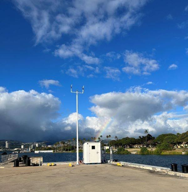
expands HarborHonolulu include NOAAs Operations Pearl Ports System
Share. Facebook Twitter LinkedIn Tumblr Telegram Email

Related Posts

Falmouth Scientific, Inc. Receives ISO 9001:2015 Quality Certification

August 21, 2025

Antarctica Undergoing Abrupt Change

August 21, 2025

Reach Subsea Completes Inspection for TotalEnergies Using USV/ Electric ROV

August 21, 2025
Top Posts

Duties of Bosun (Boatswain) on a Ship

February 1, 2025

China Fights Australia’s Plans to Reclaim Darwin Port Citing U.S. Influence

May 27, 2025

Fire-Stricken Wan Hai 503 Continues to Drift Off Indian Coast as Salvage Efforts Intensify

June 11, 2025

Sea-Doo Switch recall underway after serious safety concerns

March 2, 2025
Don't Miss
Technology

Industry Partners Deliver Largest Unified OBN Dataset in Norwegian North Sea

July 17, 2025

Unveiling OMEGA Merge: Viridien Completes Largest OBN Dataset on Norwegian Continental Shelf Viridien, in collaboration…

Kongsberg Maritime Launches K-Sail Wind-Assist Technology Solution

June 7, 2025

Noble fixes semisub work off Australia

January 2, 2025

New Jersey Offshore Wind Project Seeks Further 5-Month Planning Delay

January 1, 2025

Subscribe to Updates

Your Weekly Dive into Maritime & Energy News.

About Us
About Us

Stay informed with the latest in maritime, offshore, oil & gas, and energy industries. Explore news, trends, and insights shaping the global energy landscape.

For advertising inquiries, contact us at
info@maritime247.com.

Facebook X (Twitter) YouTube LinkedIn
Our Picks

MoU signed for 6 MW wave energy array in Spain

July 28, 2025

French containment tech selected for Purus’ new LNG carrier

June 18, 2025

Former Edda Wind boss Kenneth Walland takes the chair at Eidesvik

May 23, 2025

Subscribe to Updates

Your Weekly Dive into Maritime & Energy News.

© 2025 maritime247.com - All rights reserved.
  • Contact
  • Privacy Policy
  • Terms & Conditions
  • Advertising

Type above and press Enter to search. Press Esc to cancel.